The cruise period of a flight is a relaxed and serene time for most passengers. With the meal service over, it’s a good time to sit back and watch a film, maybe have another drink or take a nap. If you’re sitting in business or first class, you’ll probably have reclined your seat and arranged your bedding.
Safe and comfortable in your own little cocoon, it can be easy to forget that you’re actually in a pressurized metal tube hurtling through the air at 600 mph, 7 miles above the ground. As light bumps rock you to sleep, the scene at the front of the aircraft could not be more different.
Here, surrounded by the instrument panels’ glow, your pilots are wide-awake navigating the aircraft through the night sky. They know exactly how high the aircraft is, how fast it is flying and, most importantly, what lies ahead for the next several hundred miles.
At 39,000 feet, the pressures and stresses of life on the ground can seem a million miles away. Yet it’s these events, particularly the geopolitical ones, that play a major part in how a flight operates and the routes we fly.
A 10-hour flight is a lot more snooze-able in first class – see how many points away you are from a cozy, 30,000 foot slumber with the free TPG App!
In This Post
Where aircraft do and don’t fly
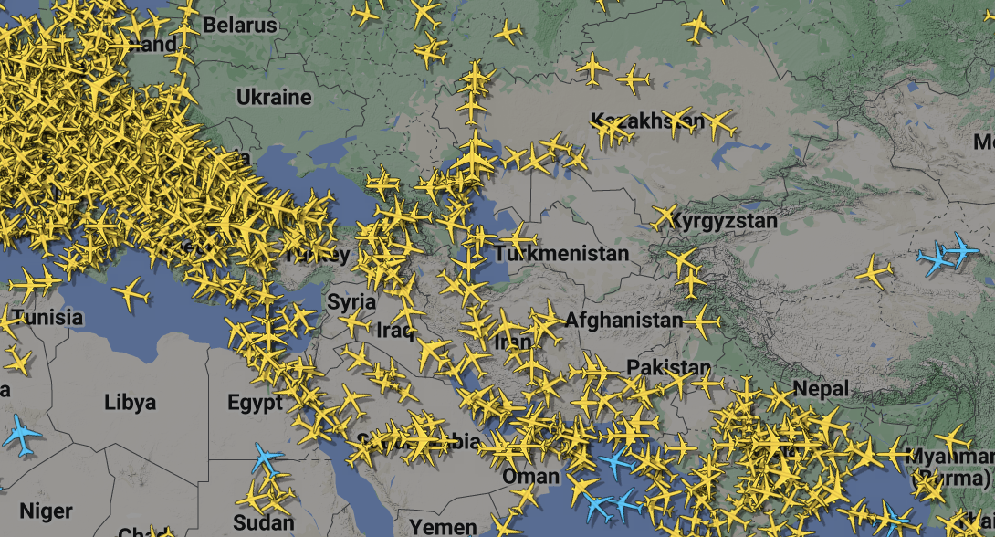
A quick look at Flightradar24 will show just how many aircraft are airborne around the world at any one time. However, what’s of more interest are the areas where there are no aircraft.
Even though aircraft are flying thousands of feet above the ground, airlines are always monitoring the security situation in the countries over which their planes are flying.
Indeed, depending on the geopolitical climate, some countries may not even be providing an air traffic service to enable aircraft to fly through their airspace.
The image above focuses on the Middle East and Western Asia — a key corridor that links much of North America and Europe with the Indian subcontinent, Eastern Asia and Australia. Almost all aircraft traveling between these areas will need to fly through this corridor.
However, a number of notable areas on the map show a lack of flights passing over them, such as Ukraine, Libya, Afghanistan, Nepal and southwestern China. In addition, there are other countries that, though we see some flights, are far more limited than other areas, such as Russia, Iraq and Iran.
This figures into the assessment that airlines make about certain routes and what would happen should one of their aircraft develop a technical problem that requires them to divert and land.
Due to these route restrictions, certain bottlenecks have developed, particularly in the route via Egypt and Saudi Arabia. This often results in air traffic control delays, or “slots,” ensuring that only a certain number of aircraft fly through that airspace in a certain time, a number which ATC can safely handle.
Consequently, airlines have been exploring other routes their aircraft can take to avoid these bottlenecks and the inevitable delays, while still ensuring the safety of all those on board. One of the most interesting of these is the route that flies over Turkmenistan, Uzbekistan, Tajikistan, Pakistan and into India.
Related: How to track where your plane is coming from before your flight
The route deliberately keeps aircraft clear of Afghan airspace, sending them along the eastern border in Tajikistani and Pakistani airspace. Those passengers still awake and watching the “moving map” channel will notice this precise route.
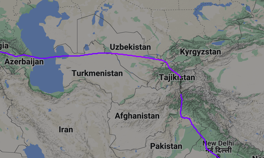
The more observant may also notice another feature of this route: The Himalayas mountain range is getting closer.
In the calm quiet of the flight deck, the approaching mountains are very much on the pilots’ minds.
Minimum Safe Altitudes
The altitude at which the aircraft is flying is in relation to the mean sea level. So, when flying over the ocean, if the plane is at 39,000 feet, then there is pretty much 39,000 feet of air between the aircraft and the water (I say “pretty much” because there are varying tolerances for air pressure changes as the aircraft moves from one area to another).
When flying over mountainous terrain, the distance between the aircraft and the closest piece of rock can be significantly reduced. For example, If a mountain is 9,000 feet high (also conveniently measured from mean sea level), even if the aircraft is at 39,000 feet there would only be 30,000 feet between the aircraft and the hill.
As a result, it’s essential for pilots to know the lowest altitude at which they can fly in a particular area while remaining clear of terrain. This is known as the minimum safe altitude, or MSA. This comes into play should the pilots need to descend for any reason.
The MSA will not only take into account the height of the mountain but also any poles or masts located on the peak. It would be tragic if the crew missed the rock but hit the 500-foot telecom mast located on the top of the hill.
As pilots fly around the world, they are always aware of the MSA in their area. Over the oceans, this is normally 2,000 feet, to take into account any large ships or ships with scientific balloons above them. On land, the MSA is much more of an issue and naturally changes with the terrain.
Related: How do pilots decide how high they fly?
When flying over mountain ranges, the MSAs can ramp up quickly. When flying over the highest and biggest mountain range in the world, the Himalayas, these MSAs can be so high they can provide serious logistical challenges for pilots.
The image below is the chart pilots have available to them on their tablet devices. It clearly shows the route around Afghan airspace and in particular the MSAs for that route, shown with the last two zeros removed.
So, through southern Tajikistan and Uzbekistan, the MSA is 198, which means the lowest safe altitude to which pilots can descend is 19,800 feet.
However, as the aircraft turn the corner and fly south, the MSA rises to 28,700 feet.

When do the MSAs come into play?
These numbers may not seem to be a problem to the casual observer. After all, if an aircraft is flying along at 39,000 feet, that’s well above even the highest of MSAs. However, a pilot’s role is not to think only about the here and now, but also about what’s ahead and to consider the “what if” scenario.
In this scenario, what if the aircraft developed a technical problem that required it to descend to a lower altitude? All of a sudden, those high MSAs are a very real consideration. So, what could require the pilots to descend?
The first scenario that probably came into your head is a loss of cabin pressurization.
Decompression
To enable you to breathe as if you were on the ground (or close to it) despite flying several miles above the surface of the earth, the cabin of an aircraft is pressurized. This means the air pressure inside the cabin is higher than the pressure in the atmosphere outside the aircraft. The “cabin altitude” for most airliners is around 7,000 feet when the aircraft is flying at 39,000 feet.
A loss of cabin pressurization, also known as decompression, results in the cabin altitude either slowly or rapidly becoming the same as the actual altitude of the aircraft. If this were to happen during the flight, it would mean the cabin altitude would become so high the occupants could not get enough oxygen into their systems and could become hypoxic.

This is why, in the event of a decompression, oxygen masks drop down to enable everyone to breathe normally.
Once everyone has their masks on, it is the job of the pilots to descend the aircraft to an altitude where the use of the mask is no longer required. This is normally between 10,000 and 14,000 feet.
However, on this route we are flying to Asia, we have a problem. The pilots want to descend to 10,000 feet but the MSA is 28,700 feet. The two are clearly not compatible.
Engine failure
The other time a descent may be required is in the event of an engine failure.
The altitude at which an airliner cruises is determined by several factors including the lift the wing can generate at the current weight, the air temperature and the power available from the engines. Add the wind details and the length of the route ahead and the flight management system will generate the optimum altitude.
However, should one of the engines need to be shut down for any reason, the power now available will be reduced either by 25% on a four-engine aircraft or by 50% on a two-engine aircraft. This in itself is not a safety issue as all aircraft are designed to fly safely in this scenario.
However, it may mean that the aircraft is no longer able to maintain its current altitude, so the pilots will have to descend to an altitude at which the remaining engine power can keep the aircraft flying safely. This is known as the drift-down altitude and it depends on the weight of the aircraft.
The heavier the aircraft, the more lift is required from the wings to fly, so more engine power is needed to keep driving it forward. As a result, the drift-down altitude will be lower. However, as the aircraft burns fuel and becomes lighter, the drift-down altitude will increase.
Related: How aircraft are designed to operate during an engine failure
The problem comes on a long flight, for example between Amsterdam and Singapore, where the drift-down altitude of an aircraft like the 787 is maybe 23,000 feet, considerably lower than the MSA of 28,700 feet.
So, in the event of a decompression or engine shutdown over areas with such high MSAs, what do pilots do? The answer is an escape route.
Escape routes
For any route with considerable MSAs such as this, the flight operations department of the airline will evaluate the worst possible scenario, namely a descent required to an altitude well below the highest MSA at any point. They will then create an escape route that allows the pilots to navigate away from the high terrain before descending to either 10,000 feet in the case of a decompression, or to the drift-down altitude in the event of an engine shutdown.
The decompression case is actually the least concerning as aircraft such as the 787 can provide all on board with oxygen for around two hours. In this case, the pilots will descend to the MSA of 28,700 feet and start to turn away from the high terrain, as prescribed by the escape route.
This plan will also inform the crew at which point it would be safe to descend to a lower altitude. As a result, if you were on an aircraft that happened to have a decompression over high terrain, you may not notice much descending going on for quite a while. This is because the pilots are ensuring that they are clear of the mountains before dropping to a lower altitude.

The engine failure situation is more critical as the aircraft will be able to maintain its current altitude for only so long. With an engine shut down, the airspeed will reduce to a point where the aircraft will start a slow drift down (hence the name) to the drift-down altitude.
As a result, it’s imperative that the pilots start guiding the aircraft onto the escape route and toward the lower ground before the aircraft flies lower than the MSA — a situation that we never want to be in.
Once away from the high terrain and over an area where the MSA is lower than 10,000 feet (in the case of decompression) or our drift-down altitude (in the case of an engine shutdown), we can relax a little more and think about the next stage of the flight: a diversion to a nearby airfield.
Bottom line
With all that is going on in the world, airlines have to explore new routes to get passengers to their destinations as efficiently as possible. However, as some of these routes take aircraft over inhospitable terrain, pilots have to be aware of their position in relation to mountains at all times.
Since safety is our No. 1 priority, we always plan for the worst possible scenario. So, in the unlikely event that it should happen, we are prepared and know exactly how to deal with the problem and keep our passengers safe.